Big Bay Local Spatial Development Framework
Image: Supplied
As the City of Cape Town invites public comment on the Big Bay Local Spatial Development Framework (LSDF), including West Beach and Erf 1117, it has faced significant resistance from various ratepayer associations and political parties demanding its review, withdrawal or extension.
They cite biodiversity violations and safety concerns regarding the Koeberg Nuclear Power Station evacuation plan, among other issues.
The City said that the LSDF, which includes West Beach and Erf 1117 (owned by the National Department of Public Works), is a community-driven initiative aimed at refining the development vision for the area.
The Big Bay area, situated between the R27 to the east and the Table View coastline to the west, is bordered by the Blaauwberg Nature Reserve to the north and Marine Circle and Blaauwberg Road to the south.
The historic heart of the area is Blaauwbergstrand Village, an 1800s fishing village featuring heritage buildings like Ons Huisie and Highclere Cottage, a MyCiTi bus service - and that its natural assets, including the scenic West Coast and a coastline such as the threatened Cape Flats Dune Strandveld and Cape Flats Sand Fynbos.
Deputy Mayor Alderman Eddie Andrews emphasized that the City revised the initial community-submitted draft to comply with policies.
“The draft LSDF for Big Bay and surrounding areas was an initiative driven by the local community. I want to inform interested parties that the City considered stakeholder comments and that there are substantial changes to the initial draft that was submitted for our vetting,” Andrews stated.
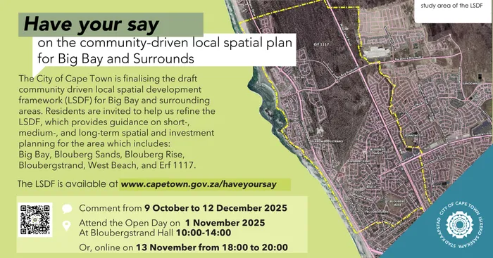
The City of Cape Town invites public comment on Big Bay Local Spatial Development Framework ( LSDF) including West Beach and Erf 1117.
Image: Supplied
Proposals include coastal protection, extending the Blaauwberg Nature Reserve, and creating biodiversity corridors.
Urban development proposals include 10 sub-precincts with tailored spatial planning, development, density, and transport proposals, Three "heart" nodes (Blaauwbergstrand Village, West Beach, Big Bay Boulevard/Cormorant Road intersection) for placemaking and social interaction, New developments must comply with Koeberg Nuclear Power Station Urgent Protection Zone mobility conditions, beachfront parking, park-and-ride strategy, tour bus route and Continuous coastal walkway from south of Marine Circle to Big Bay.
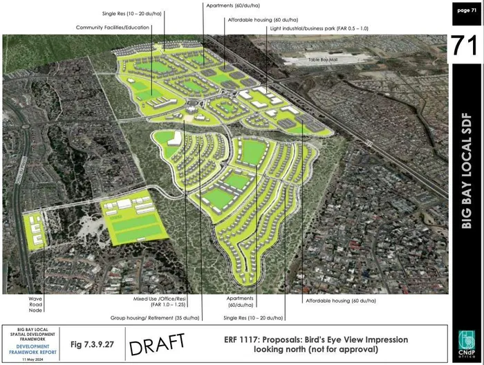
The City said Erf 1117, which is National Department of Public Works-owned land, is earmarked for housing.
“As a "Site of Coincidence," it requires environmental authorization and studies to balance conservation and urban development goals, with development phased according to road capacity for emergency evacuations from the Koeberg Urgent Protective Zone,” it added.
Jan Derksen, Chairperson of the Bloubergstrand Residents Association said the timeframe allocated was short and is asking for an extension.
“We also note that several technical components of the LSDF are still being finalised or referenced as “to follow after public participation," Derksen said.
“These include the evacuation-time modelling and population thresholds for the Koeberg UPZ, infrastructure-capacity studies, biodiversity overlays, and the implementation plan.
“Promoting Erf 1117 for high-density residential development under the LSDF directly contradicts the City’s own strategic and safety frameworks. The site lies within the Koeberg Nuclear Power Station Urgent Protective Action Planning Zone (UPZ), located between 5 km and 16 km from the plant. In this zone, national regulations require comprehensive evacuation modelling and risk assessment before any significant population increase can be approved.”
The Greater Table View Action Forum (GTAF) said it had biodiversity concerns amongst others.
“The LSDF ignores the critically endangered biodiversity on Erf 1117 and the existence of wetlands as it bulldozes through the legal protection of NEMA. The City puts profit over a sustainable environment," it said.
Michelle Collins, Chairman, Community Representation for Blaauwberg (CRB) said it strongly opposed the LSDF process.
“Evacuation Feasibility and Public Safety Ignored: Erf 1117 lies within the Koeberg Urgent Protective Zone (UPZ, 5–16 km), where national regulations demand proof that full evacuation can occur within 16 hours. Current densities in the south-east UPZ exceed international safety thresholds by five to seven times, and no updated Traffic Evacuation Model (TEM) has been disclosed,” it said.
The CRB called on the City to withdraw and release an independently reviewed Traffic Evacuation Model for public scrutiny.
Councillor Karl Bodin of the Cape Independence Party (CAPEXIT) said it rejects proposal: "It places political expedience ahead of evidence-based governance.
"Nuclear Safety Risks Ignored Erf 1117 lies inside Koeberg Nuclear Power Station’s Urgent Protective Zone (UPZ, 5–16 km radius), where Section 38 of the National Nuclear Regulator Act 47 of 1999 requires rigorous emergency-planning Measures," Bodin said.
Cape Argus